Home /
Expert Answers /
Earth Sciences /
bathymetric-contour-maps-on-the-right-is-a-bathymetric-contour-map-of-the-seafloor-off-the-coast-pa971
(Solved): Bathymetric Contour Maps On the right is a bathymetric contour map of the seafloor off the coast ...
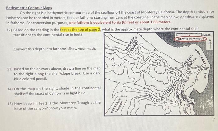
Bathymetric Contour Maps On the right is a bathymetric contour map of the seafloor off the coast of Monterey California. The depth contours (or isobaths) can be recorded in meters, feet, or fathoms starting from zero at the coastline. In the map below, depths are displayed in fathoms. For conversion purposes, one fathom is equivalent to six (6) feet or about 1.83 meters. 12) Based on the reading in the text at the top of page 2, what is the aoproximate depth where the continental shelf transitions to the continental rise in feet? Convert this depth into fathoms. Show your math. 13) Based on the answers above, draw a line on the map to the right along the shelf/slope break. Use a dark blue colored pencil. 14) On the map on the right, shade in the continental shelf off the coast of California in light blue. 15) How deep (in feet) is the Monterey Trough at the base of the canyon? Show your math.
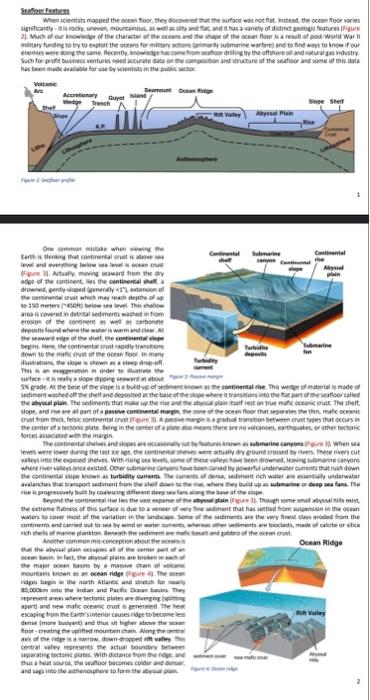
Stefloger Fentures Ore eichenen mivele when rewire the area is coweted in duevical sedmeres mathed in fiam ereston of De conerem in wet in carboning sorces aisocitid on Be margh mourkas inown a an acean ridge clpute 4. The ocrme aperti and nee mafic pceatic crust is penerned. The hes. excaging toen the Earth's imerior causes rage to becone lea central valey reareseres the achal tounaby beteres separatinc tectaeic glates. With datance tipm the fove, ane 2
Expert Answer
Based on the reading at the top of page 2, the approximate depth where the continental shelf transit...